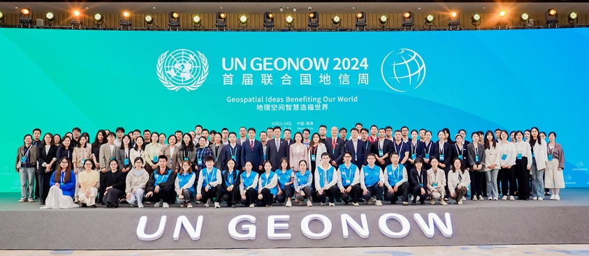
The United Nations Global Geospatial Knowledge and Innovation Centre (UN-GGKIC) convened its Geospatial knowledge and Innovation Week (GeoNow), in Deqing, China, from 21 - 24 October 2024. This inaugural edition of GeoNow under the theme "Geospatial IDEAS Benefiting Our World" brought together over 700 participants including a group of international participants who came from over 40 countries. The participants included representatives from United Nations Global Geospatial Information Management regional committees and thematic networks, United Nations system, geospatial industries, research institutions, and local government agencies and stakeholders.
The event was co-organized with the Government of Deqing County and the Moganshan Geospatial Information Laboratory in Deqing, with the support from the Ministry of Natural Resources, Government of China. It featured thematic forums known as "Moganshan Talks," which addressed topics such as geospatial knowledge, cross-border integration, strengthening digital infrastructure, and youth leadership in the geospatial field.
In making decision 14/101 at its fourteenth session from 7-9 August 2024, the Committee of Experts reiterated the importance of strengthening and enhancing national geospatial information management arrangements, capacity, capability and leadership, and urged for sustained national investments in national geospatial programs. The Centre is an office away from headquarters established by the United Nations in the Statistics Division of the Department of Economic and Social Affairs. The Centre's overarching goal is to work towards the ambitions of implementation of the United Nations Integrated Geospatial Information Framework (UN-IGIF) set by Member States, to develop capacity, promote and support the required innovation, leadership, coordination and standards to develop, strengthen, integrate and deliver national geospatial information policy, data, systems, tools, services and capabilities into their national government development policies, strategies and arrangements.
Moganshan Talks: Keynote Presentations
-
Abbas Rajabifard, University of Melbourne: PPT
Wenli Feng, China Land Surveying and Planning Institute: PPT
Orhan Altan, International Science Council GeoUnions Standing Committee on Disaster Risk Reduction: PPT
Min Chen, Nanjing Normal University: PPT
Digital Twins and Smart Cities Panel
-
Paul Cheung, National University of Singapore: PPT
Michalis Kalogiannakis, Council of European Geodetic Surveyors: PPT | Video
Nasser Khalili, University of New South Wales: PPT
Khosbayar Orosoo, Mongolian University of Science and Technology: PPT
Abbas Rajabifard, University of Melbourne; Qin Yan, Chinese Academy of Surveying and Mapping; Zhihua Zhang, Qingdao Surveying & Mapping Institute:
PPT | ReS3D V1.0 | White Paper | Video
Qin Yan, Chinese Academy of Surveying and Mapping: PPT
Smart Agriculture and Food Security Panel
-
Xiwen Luo, South China Agricultural University: PPT
Binfang Wu, Chinese Academy of Sciences: PPT
Mariana Belgiu, University of Twente: PPT
Tian Hu, Luxembourg Institute of Science and Technology: PPT
Ha Thanh Nguyen, CSIRO: PPT
Chengliang Liu, Shanghai Jiao Tong University: PPT
Natural Resources Investigation and Territorial Spatial Governance Panel
-
Livia Peiser, FAO: PPT
Mika-Petteri Torhonen, World Bank: PPT
Thiago Marra, National Institute for Agrarian Reform and Colonisation, Brazil: PPT
Chong Lin, Zhejiang Natural Resources Strategic Research Center: PPT
Bennett Rohan Mark, Dutch Cadastre, Netherland: Video
Muneeswaran Mariappan, International Union for Conservation of Nature (IUCN): PPT
Kejing Jia, China Land Surveying and Planning Institute: PPT
Uchendu Chigbu, Namibia University of Science and Technology: PPT
Michael Klaus, Hanns Seidel Foundation : Video
Clean Energy and Green Development Panel
-
Wang Guiling, Institute of Hydrogeology and Environmental Geology, CAGS: PPT
Shu Jiang, China University of Geosciences, Wuhan: PPT
Borjigin Tenger, China Geological Survey Center of oil and gas resources: PPT
Climate Change and Disaster Risk Reduction Panel
-
Siquan Yang, Ministry of Emergency Management of the People's Republic of China, China: PPT
Antonius Bambang Wijanarto, UN-GGIM-Asia-Pacific: PPT
Hamid Mehmood, ESCAP: PPT
Changjun Liu, China Institute of Water Resources and Hydropower Research: PPT
Hassan Ali, Pakistan Space & Upper Atmospheric Research Commission: PPT
-
Viliami Folau, Ministry of Lands and Natural Resources, Tonga: PPT
Cunde Xiao, Beijing Normal University: PPT
Jusong Shi, China Geological Environment Monitoring Institute: PPT
Yueqin Zhu, Ministry of Emergency Management of the People's Republic of China, China: PPT
-
Cunde Xiao, Beijing Normal University: PPT
Geo-Modeling and Geospatial Intelligence Panel
-
Paul Longley, University College London: PPT
Pankaj Kumar, Delhi University: PPT
Zhongchang Sun, International Research Centre of Big Data for Sustainable Development Goals: PPT
Lei Bai, Shanghai Artificial Intelligence Laboratory: PPT
Fulong Chen, Professor of International Centre on Space Technologies for Natural and Cultural Heritage under the Auspices of UNESCO: PPT
Zhou Huang, Peking University: PPT
Bin Yang, East China Normal University: PPT
Min Chen, Nanjing Normal University: PPT
International Symposium on Leadership Development of Global Geospatial Knowledge
-
Alexandre Caldas, UNEP: Video
Mohammed Mamman Kabir, International Federation of Surveyors - Africa Regional Network: PPT
Renzhong Guo, Shenzhen University: PPT
Salah Salih Meemar, General Authority for Survey and Geospatial Information (GEOSA), Saudi Arabia: PPT
Liping Sun, Ministry of Natural Resources, China: PPT
Abbas Rajabifard, University of Melbourne: PPT
Reports on the achievements of the Moganshan Talks
Annual sessions
- Fifteenth session
- Fourteenth session
- Thirteenth session
- Twelfth session
- Eleventh session
- Past sessions

