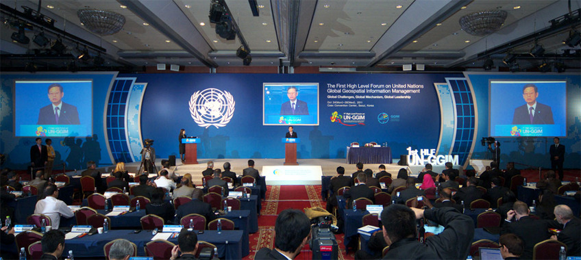
High level forum on Global Geospatial Information Management, co-organized by the Korean National Geographic Information Institute (NGII Korea) and the UN Department of Economic and Social Affairs (UN-DESA), supported by the Permanent Committee on GIS Infrastructure for Asia and the Pacific (PCGIAP), the Permanent Committee for Geospatial Data Infrastructure of the Americas (PC-IDEA) and the Committee on Development Information, Science and Technology (CODIST) for Africa.
The high level forum has provided an opportunity for in-depth discussion of current critical geospatial information issues and consultations among governments, non-governmental organizations and the private sector.
Outcome of High Level Forum on Global Geospatial Information Management (GGIM)
- Seoul Declaration on Global Geospatial Information Management
- Summary by the Chairperson, Mr. Seong-An LEEM, President, National Geographic Information Institute, Republic of Korea
Opening Addresses
- H.E. The Prime Minister of the Republic of Korea, Mr. Hwang-Sik KIM
- H.E. Under-Secretary-General of United Nations Department of Economic and Social Affairs, Mr. Sha Zukang
- H.E. President of Joint-Board of Geospatial Information Societies, Prof. William Cartwright
Ministerial Segment
- Keynote Speech
- H.E. Mr. Kwon Do-youp, Minister of Land, Transport, and Maritime Affairs, Republic of Korea
- Statements by Ministers
- H.E. Ms. Catalina Parot, Minister of National Property, Chile
- H.E. Mr. Jari Koskinen, Minister of Agriculture and Forestry, Finland
- H.E. Mr. Dato Sri Douglas Uggah Embas, Minister of Natural Resources and Environment, Malaysia
- H.E. Mr. Alpheus G. !Naruseb (MP), Minister of Lands and Resettlement, Namibia
- H.E. Mr. Thirumalachari Ramasami, Secretary of Department of Science and Technology, India
Documentation for the Meeting
- Organization of work
- List of confirmed participants (as of 26 October 2011)
- Technical Papers
- Policy Formulation and Institutional Arrangements, PC-IDEA - Paper | Slide
- Asia-Pacific Experiences in Developing Common Frameworks and Methodologies, PCGIAP - Paper | Slide
- Addressing Global Challenges Underwritten By Geospatial Data Management, JB GIS - Paper | Slide
-
A Guiding Framework for the Development of Capacity in Geospatial Information Management: the case of Africa,
CODIST/ECA - Paper | Slide - Arctic Spatial Data Infrastructure, Iceland - Slide
- Common Frameworks for Geospatial Data: The EU Approach, European Commission - Slide
- Cartographie et Géodésie Nationale, Morocco - Slide
- Common Framework & Methodology For Sdi Development, Namibia - Slide
- Development of Common Frameworks and Methodologies, Mexico - Slide
-
Enjeux Et Defis De La Formulation Des Politiques Geospatiales Et Arrangements Institutionnels En Afrique,
Burkina Faso - Paper | Slide - Challenges in Geospatial Policy Formulation & Institutional Arrangements, Australia - Slide
- Capacity Building Experiences in Global Mapping, ISCGM - Slide
- Geospatial Policy Development and Institutional Arrangements, Canada - Slide
- SDI-Challenges European perspective, Finland - Slide
- Global Challenges And Indian Initiatives, India - Slide
- Developing Common Frameworks and Methodologies, Norway, ISO/TC-211 - Slide
- Standards for Cross Community Understanding and Decision-making, OGC - Slide
- Coordination and cooperation among the countries of the Americas in matters of geospatial information, Chile - Slide
- New International Coordinating Mechanism Unified Global Geoiformation Platform, China - Slide
- International coordination and cooperation Meeting global needs, New Zealand - Slide
- The Earth is a system of systems, GEO/GEOSS - Slide
- Indonesian geoSpatialData Infrastructure (Ina-SDI) Development : Capacity Building and Technology Transfer, Indonesia - Slide
- Capacity Building and Knowledge Transfer for UN-GGIM, Republic of Korea - Slide
- Capacity Building and Knowledge Transfer: some thoughts for the future, United Kingdom - Slide
Additional Information
Photographs
Annual sessions
- Fifteenth session
- Fourteenth session
- Thirteenth session
- Twelfth session
- Eleventh session
- Past sessions

