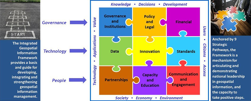
Part 3 : Country-level Action Plan (CAP) is specific to each country and details 'how' the guidance, options, and actions recommended in the Implementation Guide will be carried out, when and by whom. This Part contains the processes, resource materials, templates and examples that are available and helpful to first develop a national action plan, and then operationalize the UN-IGIF through its subsequent implementation, very importantly aligned with national priorities and cognizant of national circumstances.
Countries operationalize the UN-IGIF with their own CAPs that align with their countries' priorities and circumstances. A CAP addresses each of the nine strategic pathways while considering the strategic and operational needs of a country when operationalizing the UN-IGIF. Importantly, the CAP is a plan, not a program that is implemented. Each CAP is unique to a country, as it determines where they currently are in their capacity and capabilities, and reflects decisions made to advance and/or enhance national geospatial capabilities within that country, and where they want to be after planning for their integrated geospatial information management.
Preparing and developing a country-level Action PlanTo prepare and develop a country-level Action Plan tailored to national circumstances and priorities, an approach is needed that references the specific guidance, options and recommended actions provided in Part 2: Implementation Guide and addresses each of the nine strategic pathways.
The United Nations through a Development Account Project (Project 1819D) conceptualized, developed and piloted an approach towards preparing and developing a country-level Action Plan. The approach and related tasks are designed to consider national circumstances by recognizing that one size does not fit all. Importantly, the approach allows countries to assess and analyze, discover and learn their national circumstances, before designing and developing their action plans.
This approach was developed out of the need to consider existing, and then developing new capacity and capabilities as a critical feature when implementing the UN-IGIF. The approach is intended to be inclusive and participatory, and one where existing institutional capacity and capabilities are recognized, and where capacity and capability development commences with the very first component, gradually maturing when successive tasks are undertaken.
Recommended tasks and resource materials
The approach, presently, has three components with a set of recommended tasks complemented by a suite of resource materials for countries to reference. These resource materials are meant for countries to consider, reference and tailor to their national circumstances when assessing and analyzing their national situations before designing and developing their country-level Action Plans. The resource materials, intended to support country-level understanding of geospatial priorities and opportunities, needs and gaps, are to be tailored to individual national circumstance.
The tasks are recommended and not mandatory, are all adaptable, again, to national circumstances. The recommended tasks for the development of the country-level Action Plans with related resource materials -
- 1) Project Initiation and Pre-needs Assessment
- 2) Stakeholder Identification and Analysis - English
- 3) Plan of Action (to design and develop country-level Action Plan) - English
- 4) Current and Desired (or Future) Situation Assessment - English
- 5) Baseline Survey - English
- 6) Environmental Scanning and Analysis (for understanding national situation) - English
- 7) Stakeholder Engagement Workshop - English
- 8) Strategic Alignment (and Benefits) Exercise - English
- 9) Vision, Mission and Goals - English
- 10) Gap Analysis Matrix - English
- 11) Needs Assessment and Gap Analysis Report - English
- 12) Country-level Action Plan (Template) - English
- 13) Strategic Pathway Actions and Activities - English
- 14) Implementation Schedule
- 15) Budget Estimations
- 16) Success Indicators
Countries implement the United Nations Integrated Geospatial Information Framework (UN-IGIF) with their own country-level Action Plans prepared with due consideration for their national circumstances and priorities. These national country-level Action Plans are provided by an entity in a Member States and are neither reviewed nor edited by the Secretariat. These Action Plans facilitate the exchange of information, can serve as useful examples, and may also serve as additional reference and resource materials for the preparation and development of country-level Action Plans.
Please note that the contents of the Action Plans do not reflect the position of the United Nations Secretariat. The designations employed and the presentation of material does not imply the expression of any opinion whatsoever on the part of the United Nations Secretariat concerning the legal status of any country, city, or area, or of its authorities, concerning the appellation of places, or concerning the delimitation of its frontiers or boundaries.


