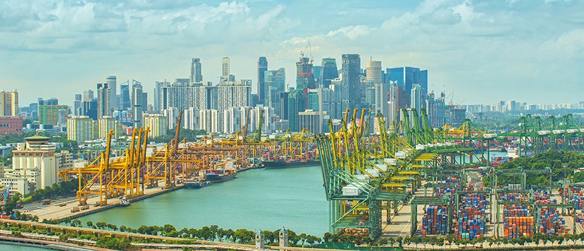
Third Expert Meeting of the Working Group on Marine Geospatial Information and International Seminar on United Nations Global Geospatial Information Management
Singapore- 9 - 13 May 2022
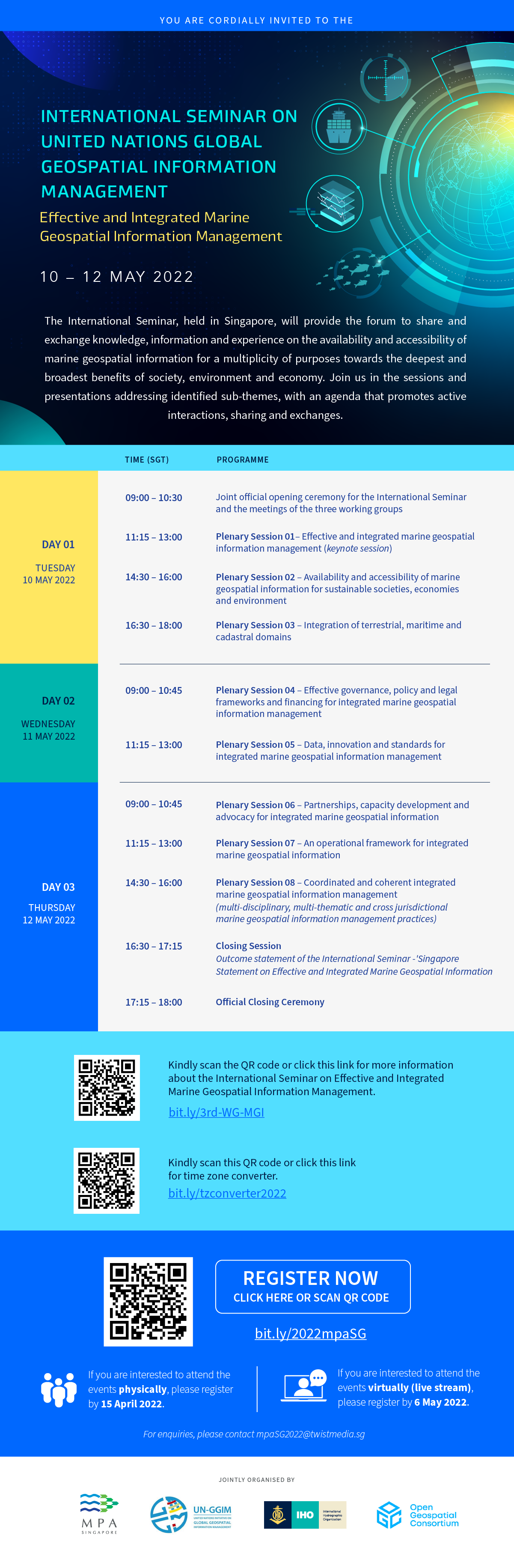
The United Nations Global Geospatial Information Management Section, Statistics Division, Department of Economic and Social Affairs and the Government of Singapore through the Maritime and Port Authority of Singapore successfully organized the third expert meeting of the Working Group on Marine Geospatial Information together with the thirteenth meeting of the Marine Spatial Data Infrastructure Working Group of the International Hydrographic Organization and the meeting of the Marine Domain Working Group of the Open Geospatial Consortium. These meetings incorporated a global forum, the International Seminar on United Nations Global Geospatial Information Management with the theme "effective and integrated marine geospatial information management". The five-day event was very productive, participants affirmed the Singapore Statement on Effective and Integrated Marine Geospatial Information Management, the outcome statement of the International Seminar.
The third expert meeting of the United Nations Working Group on Marine Geospatial Information allowed members of the Working Group together with invited experts to review, consider and discuss its progress to-date, followed through on the guidance and decisions of UN-GGIM at its annual sessions, considered and addressed new developments, and in particular, its ongoing consideration to develop and consult the draft Operational Framework for Integrated Marine Geospatial Information Management (IGIF-H). The meeting facilitated peer-to-peer engagement and exchange of knowledge, information, experience as well as practices. Members of the Working Group also attended to the business of the Working Group.
The International Seminar on United Nations Global Geospatial Information Management, with the theme "Effective and Integrated Marine Geospatial Information", had an opening keynote presentation by the Chief Executive Officer of the Maritime and Port Authority of Singapore together with twenty-nine presentations delivered in eight plenary sessions. The seminar provided a forum for dialogue, exchanging and sharing of knowledge, information and practices. It allowed participants to deliberate key considerations for integrated marine geospatial information within a national digital information ecosystem for effective policy-development, decision-making, programmes and projects to achieve national development priorities and the Sustainable Development Goals.
Marine geospatial information must be readily available and accessible, needed by Member States to support data-driven, evidence-based management and administration of seas, oceans, coastal zones, and inland waters. Knowing where people, marine life, events, and activities are, and their spatial relationships to one another, is essential for informed policy-development and decision-making. The timeliness of such data is of equal importance. Real-time marine geospatial information is needed to prepare for and respond to emergency situations, such as disasters, but real-time or near real-time data can also help develop strategic priorities and measure and monitor outcomes, including the 2030 Agenda for Sustainable Development.
Documentation
- Singapore Statement on effective and integrated marine geospatial information management
- Concept Note and Outline Programme (updated as of 4 April)
- Third expert meeting - Provisional annotated agenda and Organization of the meeting
- Provisional annotated agenda (International Seminar)
- Information - Travel methods for Singapore (updated as of 4 April)
- Information Note (updated as of 4 April)
- Provisional List of Participants
- Summary Report
Tuesday 10 May 2022
-
Session #1: Effective and integrated marine geospatial information management
- The IHO Marine Spatial Data Infrastructures Working Group. (MSDIWG)
- Mr. Jens Peter Hartmann, Danish Geodata Agency, Denmark
- Time and Talent of Essence: The Case for Integrated Marine Geospatial Information
- Mr. Koh Lian Pin, National University of Singapore
- The role of the National Hydrographic Service
- Mr. Massimiliano Nannini, Italian Hydrographic Institute, Italy
- Effective and integrated marine geospatial information management
- Mr. Mathias Jonas and Mr. Leonel Manteigas, International Hydrographic Organization
-
Session #2: Availability and accessibility of marine geospatial information for sustainable societies, economies and environment
- National Geospatial-Intelligence Agency (NGA) Disaster Response and Data Availability
- Ms. Caitlin Johnson, National Oceanic and Atmoshperic Administration, United States of America
- A brief overview of the Seabed 2030 Project, IHO DCDB & CSB Activities
- Mr. Jace Ebben, National Geospatial Intelligence Agency, United States of America
- Marine Environment Sensing Network: Expanding Singapore's marine monitoring network for research, education, and collaborations
- Ms. Jani Tanzil, National University of Singapore, Singapore
- Offshore wind for a sustainable ocean economy: the key role of geospatial data systems for marine spatial energy planning
- Mr. Paul Elsner, University of London Birkbeck
-
Session #3: Integration of terrestrial, maritime and cadastral domains
- Geodata in Sweden Cooperation and Development
- Ms. Magdalena Andersson and Ms. Johanna Fröjdenlund, Lantmäteriet, Sweden
- Hydrographic Survey and Geospatial Information
- Mr. Saud Al-Ruways, General Authority for Survey and Geospatial Information, Saudi Arabia
- Integration of Terrestial, Maritime and Cadastral Geospatial Information
- Mr. Victor Khoo, Singapore Land Authority, Singapore
Wednesday 11 May 2022
-
Session #4: Effective governance, policy and legal frameworks and financing for integrated marine geospatial information management
- Geospatial information to value cosatal nature-based solutions
- Mr. Dan Friess, National University of Singapore, Singapore
- Bathymetric Data Licensing For the NOAA Office of Coast Survey
- Mr. John Nyberg, National Oceanic and Atmospheric Administration, United States of America
- ROK MSDI
- Mr. Myeonghun Jeong, Chosun University, Republic of Korea
- Integrating Spatial Data Infrastructure
- Ms. Yidda Handal, Cartography and Geography, Property Institute, Honduras
-
Session #5: Data, innovation and standards for integrated marine geospatial information management
- Enhancing Marine Geospatial Data with Digital Twin of the Met-Ocean Environment
- Mr. Jeng Hei CHOW, Technology Centre for Offshore and Marine, Singapore
- Evolution of ISA Data Management Strategy Deep Dive into Seabed Geospatial Data Management
- Mr. Sheldon Carter, International Seabed Authority
- Innovation for Hydrospatial Information Management - IHO and OGC The Story so far
- Mr. Trevor Taylor, Open Geospatial Consortium
-
Session #6: Partnerships, capacity development and advocacy for integrated marine geospatial information management
- Pacific Geospatial and Surveying Council
- Mr. Andrick Lal, Pacific Community (SPC)
- Capacity Building Challenges and Initiatives
- Mr. Leonel Manteigas, International Hydrographic Organization
- The Italian capacity development programme in the Mediterranean region
- Mr. Nicola Marco Pizzeghello, Instituto Idrografico della Marina, Italy
- Partnerships, Capacity Development and Advocacy for Integrated Marine Geospatial Information Management
- Mr. Parry Oei, Maritime and Port Authority of Singapore, Singapore
-
Session #7: An operational framework for integrated marine geospatial information management
- IGIF-H Operational Framework for Integrated Marine Geospatial Information Management
- Mr. John Nyberg, National Oceanic and Atmospheric Administration, United States of America
- The case for change - integrate, integrate, integrate
- Mr. Jonathan Pritchard, Open Geospatial Consortium
- Precision Marine Navigation Information Infrastructure for the New Blue Economy
- Ms. Julia Powell, National Oceanic and Atmoshperic Administration, United States of America
-
Session #8: Coordinated and coherent integrated marine geospatial information management
- On the need for marine geospatial information for monitoring coastal hazards, sea level rise, or geomorphological processes
- Mr. Adam D Switzer, Nanyang Technological University, Singapore
- Mariners' Routeing Guides Practical examples of presentation of coordinated and coherent integrated marine geospatial infrastructure
- Mr. Jens Schröder-Fürstenberg, Nautical Information Service, Germany
- Marine Data Sharing and Collaboration: The Keys for a Successful Hydrospatial Strategy Implementation
- Mr. Rafael Ponce, Esri
- Artificial Intelligence based Real-Time Sea Surface Currents Quantification and Dissemination Framework
- Mr. Vladan Babovic, National University of Singapore, Singapore