Sixth High Level Forum on United Nations Global Geospatial Information Management
Windsor, United Kingdom
Virtual High Level Forum Sessions
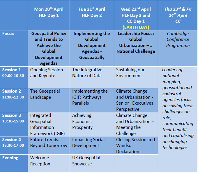
With reference to our communication on the postponement of the Sixth High Level Forum on 12 March 2020, we indicated that we were exploring whether it is possible to conduct some aspects of the programme virtually using webinars during the week of 20th April when the Forum was originally scheduled.
We have been working on the logistics to deliver some of the valuable content we had planned for the Forum as an exciting virtual event. Whilst we are on track to deliver this content, we also realize that the April dates may now be too early. In part, this is because of the need to properly and adequately prepare, including the technology, for this virtual event that may now have a much larger audience. We are also cognizant of the dynamic situation at this time globally. We will come back to you with confirmed dates in due course when arrangements are in place.
However, we would like to share with you our planning for the virtual event, still intending to focus on the overarching geospatial landscape, the Integrated Geospatial Information Framework and the Future Trends report. Presently, we are planning on three sessions of 2-3 hours each, and on three separate days, probably at weekly intervals. We intend to hold them in a time window which we hope will be relatively comfortable for the majority of us around the globe. We are also planning for each of the sessions to be recorded for all to be able to view later.
The three sessions will be as follows:- Session 1 - Strategic Day - The Geospatial Landscape and overview of Integrated Geospatial Information Framework and Future Trends;
- Session 2 - Integrated Geospatial Information Framework Day - IGIF in detail, the pathways and the national action plans; and
- Session 3 - Future Trends Day - Future Trends in detail, the relevance and application to national action plans and priorities.
We will provide more information in the coming weeks, and thank you for your continued understanding and support, especially for those who have shown patience as we considered our options during the past few weeks.
- Announcement - (12 March 2020)
Documentation for the Sixth High Level Forum
- Announcement Letter
- Concept Note
- Information Note
- Provisional Annotated Agenda (forthcoming)
Outcome of the Sixth High Level Forum
- Windsor Declaration
Opening Statements
Presentation Materials
We regret to inform you that the United Nations Statistics Division, as Secretariat for the Committee of Experts on Global Geospatial Information Management, and Ordnance Survey of Great Britain have jointly agreed that it is no longer possible to proceed with the Sixth High-Level Forum on United Nations Global Geospatial Information Management, scheduled to be held in Windsor, United Kingdom from 20 - 22 April 2020.
In the context of the growing global health crisis posed by the spread of the COVID-19 (coronavirus) outbreak, and the World Health Organization's declaration of a global pandemic on 11 March, we believe it is in everyone's best interest to make this difficult announcement now.
We understand that colleagues were looking forward to participating in the High-Level Forum. However, we are also aware that many participants and invited speakers are increasingly anxious with the evolving COVID-19 outbreak situation, and the related health and travel measures being implemented around the world. We have been monitoring the situation closely and have taken the difficult decision that it is no longer feasible to run a successful event. We believe this is the right decision to announce at this moment of time.
We sincerely thank the global geospatial information community for considering, planning and preparing to participate and contribute to the Sixth High-Level Forum, and to everyone involved in the planning, preparation and organization of this major event during the last 18 months. We also appreciate that some participants will have committed to travel plans and recognize the inconvenience that this news may cause.
We are working hard to explore whether it is possible to conduct some aspects of the programme virtually using webinars - for example, the launch of the Implementation Guide of the Integrated Geospatial Information Framework and the Third Review of the Future Trends impacting the global geospatial sector. We commit to keeping you updated on our plans over the coming weeks. However, in the meantime we would encourage members of the global geospatial information community to consider keeping availability in your calendar on Monday 20th and Tuesday 21st April in anticipation of such an invitation.
Cognizant of the dynamic situation at this time, we thank you for your continued understanding and support, especially for those who have shown patience as we considered our options during the past few weeks. We would like to take this opportunity to wish you well and trust that our decision not to proceed with the High-Level Forum will, in some small way, contribute positively to the global fight to combat the spread and impact of the COVID-19 pandemic.
12 March 2020

