The Committee of Experts on Global Geospatial Information Management at its tenth session adopted the Implementation Guide of the United Nations Integrated Geospatial Information Framework (UN-IGIF), subject to further refinement and finalization, as a means of strengthening national geospatial information management arrangements within and across Member States at the institutional level and supporting the implementation of the Sustainable Development Goals, especially in developing countries. The Committee of Experts noted the global significance of the Framework, which served as a key umbrella for the many activities under its purview, including regional committees and thematic groups, which could be applied to any country to guide transformational change.
Strengthening national geospatial information management arrangements in countries, developing countries in particular, can be achieved through the implementation of an integrated approach to geospatial information management, aligned to national strategies and arrangements, and anchored into national development priorities. The UN-IGIF is a multi-dimensional United Nations mandated Framework, aimed at strengthening national geospatial information management arrangements in countries, that responds to clear policy needs. The UN-IGIF acts as a catalyst for economic growth and opportunity, and stimulates improved decision-making for national development priorities and the Sustainable Development Goals (SDGs).
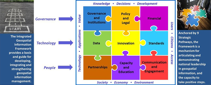
As an intergovernmental blueprint, the UN-IGIF comprises three components; an overarching strategy, implementation guidance, and action plans at the country level. The Overarching Strategy sets the context of 'why' geospatial information management needs to be strengthened and why it is a critical element of a nation's national priorities and development. It focusses on the role of geospatial information in the digital age and how that information is integral to government functions at all levels. The UN-IGIF communicates this via vision and mission statements, seven principles, eight goals and nine strategic pathways. However, through the Implementation Guide, anchored by the nine strategic pathways, the UN-IGIF provides the guidance on 'what' actions can be undertaken to 'integrate' geospatial information with any other meaningful data to solve societal and environmental problems, and to provide understanding and benefit from a country's national priorities and development and the SDGs. The Country-level Action Plan references the specific guidance, options and actions provided in the Implementation Guide, and is the process of building a UN-IGIF for a nation, beginning with specific plans that align with a country's national priorities and circumstances. The country-level Action Plan, is specific to each country, detail 'how' the guiding principles, options, and actions recommended in the Implementation Guide will be carried out, when and by whom. The country-level Action Plan can be viewed as the 'requirements document' for national implementation.
Importantly, the UN-IGIF is not an infrastructure. It is a standalone 'framework', independent of national spatial data infrastructures (NSDIs) and other infrastructures. That said, the UN-IGIF fundamentally recognizes, builds substantially upon, and augments previous investments and achievements in planning and implementing NSDIs. Beyond the traditional NSDI concepts and architecture, the UN-IGIF focuses on the governance, legal, financial, capacity, and engagement processes necessary to collect, maintain, share and integrate geospatial information, through all levels of government and society, in a modern and enabling technology environment. This approach contributes to understanding capacity and capability shortcomings while building a more sustainable national geospatial information management program, aligned to national priorities and circumstances within a country.